‘Tis the season of mists and not so mellow busyness. With the Irish holiday now a dim and distant memory, what have I been up to over the past month? The problem with extended holidays is that the work gets squeezed into the days when I am home. This means that I have been giving talks almost daily since arriving home. This included a plagues and epidemics session for the Society of Genealogists’ ‘Sick London’ course. Having spent a few days with the descendants, I was generously given some real germs, so was able to add verisimilitude by coughing and spluttering my way through this one. For those wanting more germs, my Sickness and Death online course for Pharos Tutors starts soon and there room for more to join in the fun. Next year is already looking ridiculously busy, with forty five talk bookings and I have even taken a booking for 2025. It is all a bit ‘stop the world, I want to get off’.
It has also been Christmas cake and pudding making time. I will draw a veil over why we ended up with industrial amounts of ground almond, which I don’t even like but we did. I offered to donate some of the excess to the descendants. This meant travelling with small bags of white powder and hoping the car wouldn’t need to be searched for any reason.
Now this year’s holiday is past, it is time to look to next year, when we hope to plan to return to Northumberland and Scotland. Cue revisiting my children’s Scottish ancestry and managing to add a couple of new generations. If I were to believe umpteen online family trees, I too have Scottish ancestry but I don’t feel I have enough evidence to make that link. Right (fairly unusual) name, rightish date, no other candidates, seventy miles away – could be him give me something linking these two men somewhere please and as for the longstanding ‘almost crumbling’ Northumbrian brick wall…….. I may never know if my John Hogg is the John Hogg I am almost certain he must be. Still, it wouldn’t do if it was all to easy would it.
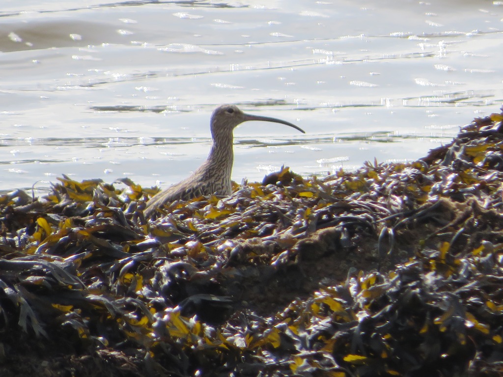
The sun was back with us for our last full day so we set off for Kinsale and were only slightly fooled by the new road layout on the outskirts of Cork. Finally at Kinsale we were able to find some working fishing boats for a fisherman of my acquaintance to study. Ireland does seem to have a shortage of public toilets but we located one in Kinsale. It was one of those pod type ones and cost €1 for twenty minutes. We won’t go into why anyone could possibly want twenty minutes but I know some people take an inordinately long time; I am usually standing behind several of them in a queue. €1 did seem rather a lot and we only had one 1 euro coin between us. We hoped that if I went in first and came out again within the allotted twenty minutes the other member of our party could follow me in. Unfortunately, it didn’t work like that and you couldn’t reclose the door for a second person. I’ll just leave that there. Just outside Kinsale there were mud flats with some wading birds for me to take fuzzy photos off. In my defence I was about 100 metres away and the sun was in the wrong direction.
Day 34
We weren’t due at the ferry terminal until the evening but with a long drive ahead we didn’t want to go far, especially as it was raining again. We drove to nearby Ballycotton where there were more fishing boats to examine. One thing we have noticed is that gardens here are usually fairly plain but virtually every one has hydrangeas, if nothing else.
Packing up the van was quickly accomplished, we are dab hands at this and we set off for the ferry terminal. We were directed to lane 19. We joined the end of the queue in lane 19, which was full. An excitable terminal employee braved the driving rain to let us know we were about to head off to Dunkirk; we were in fact in lane 20. The final lane 20 car was across two lanes obscuring the numbers. Adjustments made, we ended up in lane 19 next to a convoy of jeeps taking aid to Ukraine. I attempted to access the limited (20 minutes) free wifi on the ferry. This proved impossible. After I had taken up four minutes of my allotted time complying with repeated requests to put in my details, without actually being connected, I gave up. The driver amongst us was supposed to be sleeping. He normally sleeps as soon as he sits down but because he needed to sleep this time he was remarkably wakeful.
Day 35
We arrived in Pembroke at 1.15am and headed for home, planning to stop at any sign of tiredness from the driver; there was none. Bless him, we arrived home at 6.48am having done 3630 miles since we left. There are thirty two historic counties in Ireland. We stayed in nine, visited another nine and travelled through four more, which isn’t a bad haul.
I promised you my top ten days out and it was a difficult choice but here they are:
Ulster American Folk Park
Strokesdown Park House and Famine Museum
Ring of Kerry with Dunloe Gap (only this high because of Dunloe Gap)
Irish National Heritage Park
Dingle Peninsula
Donegal
Connemara and National Museum of Rural Life
Newgrange
Rock of Cashel
Giant’s Causeway
And that’s the lot, thanks for coming along for the ride. Normal ramblings of an historical nature will resume shortly, if anything about my life can actually be called ‘normal’.
This was not really a great day for going anywhere weather wise. Undaunted, well may just a little bit daunted, we set off for Blarney Castle. In the early thirteenth century a stone structure replaced the tenth century wooden hunting lodge on the site. The stone building was demolished in the mid fifteenth century, so Dermot McCarthy could use the stone for the current tower house or castle. Like so many others, the castle fell to the Parliamentarians in the English Civil War. Although the castle was restored to the McCarthys by Charles II, it was once again confiscated by William III, as the Catholic McCarthys supported James II. Caves beneath the tower are known as the Badger Caves and several legends are associated with them, with tales of prisoners being thrown into a pit in the caves and passages from the caves leading to Cork and Kerry. The inhabitants are supposed to have escaped with their valuables down these passages in Cromwell’s time, leaving little for his troops to loot.
We thought that the entrance fee was a bit on the steep side, especially as you would normally have to pay to park as well. The machines were out of order so we escaped this. Of course the tourist honey pot here is the Blarney Stone, which has been kissed by tourists for over two hundred years, in order to be rewarded with the gift of the gab. Allegedly Queen Elizabeth I associated the word Blarney with smooth talking flattery because the then lord of the castle Cormac MacDiramada, tried to persuade the queen of his loyalty to prevent her from seizing Blarney for the crown. She shrewdly saw through his sycophancy.
There were signs warning visitors of the ‘arduous’ climb to the stone, which is at the top of the castle on the battlements. They aren’t wrong about this. Clambering up what I think was four floors worth of very narrow spiral steps that were slippery with rain was possibly not one of my better ideas. Be warned, this is an all or nothing climb, once you are on the path to the top there doesn’t seem to be any option to bail out half way. We passed on the kissing the stone thing, not least because I talk too much anyway, although I don’t think I am guilty of ‘smooth talking flattery’. Kissing the stone involves taking off glasses and emptying pockets in case anything falls out, false teeth weren’t mentioned but maybe those are in peril too. You then lie down on what was on the day of our visit a very soggy mat and bend backwards with your head considerably lower than your bottom, supporting yourself by gripping on to metal bars. The men who were disinfecting the stone between kisses and hanging on to people to stop them plunging head first to their doom had prominently displayed bowls for tips and then you could pay more for photos (I heard the sum of €10 mentioned) that were taken of you in a very strange position. It all seemed a bit like fleecing gullible tourists to me. To be fair, the gardens and grounds were extensive and we did explore a little. I was particularly keen on the poison garden. Blarney House, built in 1874, is on the site but is not open to the public. In half decent weather woodland and riverside walks would have given us better value for our entrance money.
As we were unable to go to Craggaunowen because it had shut for the season before we got near enough and we combined Rock of Cashel and Kilkenny in one day, we were left with two spare days. The original plan was to visit Waterford on the way to the ferry but now we were able to give it a day to itself and just as well as we could never have parked the car and caravan. We opted to avoid the toll road again and after a sunny drive, approached Waterford via an industrial estate. We found a car park but were only able to park for two hours, which was a shame as Medieval Waterford had a great deal to offer. Understandably, they make a great deal of their Viking heritage. There were also several building with murals.
We had a variety of museums to choose from; these were clustered together close to the cathedral. Should it be the Time Museum, The Irish Wake Museum or the Silver Museum? I was tempted by the virtual reality Viking experience but I am not sure how well virtual reality goggles go with glasses so we went for the tamer option of the Medieval Museum, which was very good. You are able to buy combined tickets for more than one museum, which seems like a good idea for those who want to go to more than one. We had already passed the Franciscan friary that Henry III agreed to the build in 1241. Richard II stayed here when he visited in 1394. After the dissolution, Henry VIII allowed a Catholic alms house to be built, where prayers were said for Henry VIII’s soul until the mid twentieth century. William III encouraged the Huguenots to settle in Ireland and there was a community in Waterford who used part of the friary as their church.
Inside the museum, photography was tricky as, understandably, light was low, no flash was allowed and there was reflection from the glass cases. We saw the cloisters and the wine cellar, which had a wattle and daub roof. There were many of the city’s charters on display and a list of mayors dating back to 1284; the first female mayor was not elected until 1991.
This part of Ireland was one of the first to be settled and it is believed that the Mesolithic settlers came from Wales c.7700 BCE. 10,000 artefacts were found in Bally Lough during a project in the 1980s and 1990s. The Medieval city was walled, with several towers, of different dates, along its length. Reginald’s Tower, which is mentioned as a stone structure in 1088, was where the city’s Viking leaders were taken during the Anglo-Norman invasion of 1170; two were executed there. The tower was rebuilt by King John and an additional two floors were added in the fifteenth century.
In the thirteenth century, Waterford was granted a monopoly for the importation of wine, so all wine imports in southern Ireland had to come through the port. This led to great rivalry with the neighbouring port of New Ross and smuggling took place. Initially, the wine came from France but during the Hundred Years’ War, Iberian wine predominated. The Great Charter Roll, which was on display, was put together to convince the king of the city’s long standing association with the crown and to ensure that it continued to be favoured over New Ross. The main exports were woollen rugs and cloaks. In 1566, woman were forbidden from being wine taverners or drawers (the equivalent of barmaids) because of their bad reputation in the taverns. ‘Naughty corrupt women’ were leading ‘honest damsels into folly’.
Apparently, Perkin Warbeck, a pretender to Henry VII’s throne, besieged the city in 1495, supported by the 9th Earl of Desmond, from Cork and foreign mercenaries. Cannon in Reginald’s tower fired on the invaders’ ships and two were sunk. This is the earliest record of cannon being used in Ireland. After eleven days the besiegers were defeated and Warbeck escaped; Desmond was pardoned. Although Waterford was the only town not to succumb to Cromwell himself, it was taken in 1650 by Cromwell’s son-in-law Henry Ireton, when the citizens were weakened by plague. The city was looted but incredibly, fifteenth century vestments survived because they had been hidden in a secret chamber under the cathedral’s floor. They were not rediscovered until 1773 when the medieval cathedral was demolished and the current one was built. These were on display in very dim light but were intricately and lavishly embroidered and must have been very heavy to wear. We saw the Great Parchment Book of Waterford, chronicling activities in the city from 1356-1649. The entry declaring Charles II to be king upon the execution of his father was erased when the city was taken by Cromwell’s New Model Army.
We travelled back along the small coastal roads in order to have some different scenery for part of the way. Our sojourn at the Victorian Farm is over, so we began to work our way through the first series of Coast in the evenings.
We seemed to have survived Storm Agnes unscathed so headed off for Cobh, which I was pronouncing Cob but is apparently pronounced Cobe, to rhyme with robe. The railway station at Cobh aka Queenstown has been converted into a heritage centre that commemorates Irish emigration; over three million people left from Queenstown between 1815 and 1970. We were attracted by the signs to a free car park, which looked like it was going to be a fair way from the centre but turned out to loop back so as not to be, so we were glad that we resisted the lure of paid for on street parking.
There is a statue outside the centre that commemorates Annie Moore, a fifteen year old girl from Cork who was the first person to go through the immigration centre at Ellis Island, where there is also a statue of her. You can book a hour’s consultation with a genealogist at the centre for an eye watering €80. I need to put my prices up! We’d barely got through the door when Chris somehow got into conversation with someone who had been at the same school as he had and knew people he knew. I am used to this happening at home but this did seem to be quite a coincidence.
On admission to the centre we were given tickets bearing the name of a real emigrant and the actual ship on which they sailed. These emigrants left Ireland and different times in history and we were told that we would find out their fate as we went round the museum. We were both given tickets for the Titanic, so realised that this probably wasn’t going to end happily. Chris’ character was a twenty year old who eloped with a young eighteen year old to avoid being shot by her disapproving family. It is allegedly their story that inspired the film Titanic. I on the other hand was a widowed mother of five, Margaret Rice, who had been back to Ireland on a visit following the death of her husband with whom she had emigrated in 1899.
The exhibition was very well done and the personal stories were an effective touch. Several waves of emigration and emigrant ships were highlighted. Two hundred political prisoners were sentenced to transportation to Virginia in 1620. They had marched to Dublin to protest at being dispossessed of their land when Sir Arthur Chichester ‘planted’ Protestants in Wexford. From the mid-seventeenth century, Spike Island was used as a holding centre for those awaiting transportation. Many were also leaving as indentured servants. Cromwell was responsible for sending huge numbers of men, women and children to America and the West Indies, many of whose only crime was to be Irish. Kidnappers were offered substantial rewards for everyone they delivered for transportation. With around 50,000 people sent overseas in this way and sold to plantations between 1652 and 1659, in total it is estimated that Cromwell removed half a million Irish people through transportation, murder and starvation, in what was effectively an ethnic cleansing measure. In 1798, over six hundred United Irishmen were transported to Australia following an uprising. I was aware of the Roses from the Heart project to commemorate female convicts to Australia by embroidering bonnets in their name. 25,566 bonnets have been made and some were on display.
The emigrants who left from Cobh in the 1820s, many of whom went to Canada, were also part of the story. Cobh was, of course, the last port of call for the Titanic before she sailed and there was a memorial to all those from Ireland who embarked, the vast majority of whom perished, including our characters. I was pleased to see a photograph of my Margaret and her five sons. I wonder how that survived as the whole family were lost. Only Margaret’s body was recovered; she is buried in Halifax, Nova Scotia. The Lusitania, torpedoed off the Cork coast during the second world war was another disaster that was commemorated in the exhibition. 1198 of the 1959 passengers died and survivors were cared for in Queenstown and Kinsale.
Next was a bit of a drive to the supermarket of our choice. Slightly more of a drive than we’d intended because the satnav was fooled by the new road layout. We did pass some mud flats, where I glimpsed birdlife, including egrets, snipe and oyster catchers, which has been sadly lacking on this trip. On this day we clocked up more than 3000 miles since leaving home.
Fortunately, the predicted overnight storm wasn’t too bad so we could begin our day’s adventures. Another day, another ring, this time the Ring of Beara but first to travel south to reach it. We, ok I, decided to cross the Kerry peninsula, rather than going round the main road, which we had travelled on before. In order to do so I set the satnav to follow the shortest route instead of the fastest. Do we want it to warn us of unsuitable roads? Yes, probably. The satnav makes a bleeping sound. Turns out that was it warning us, who knew? We wound our way up into the mountains until the road gave out. In theory it was a road, both map and satnav were agreed on this but it was a very narrow, bumpy, unmade-up track. Allegedly it went on for at least three miles. Having not realised this was a mistake in time to reverse back out of our predicament, we persevered amidst mutterings about the impact on the suspension. It was a mile before there was space to do a many point turn without falling over a cliff or in a bog. We took a slightly less short route but one that had the advantage of tarmac. This led us past Lough Caragh and across what is allegedly Ireland’s highest mountain range. The sum total of traffic that we encountered in an hour’s driving was one tractor. A rough road (but a least it was a road) and a series of tunnels took us to the eastern edge of the Ring of Beara and into County Cork.
The Ring was another scenic drive, similarly devoid of suitable places for comfort stops as the Ring of Kerry. There were lovely views over Bantry Bay. Many houses were painted yellow, perhaps there was a job lot of paint going cheap. As we reached the north coast, there were large mussel farms. I had hoped that our route would take us along the small portion of the Ring of Kerry that we missed in order to go through the Dunloe gap but by this time the satnav was firmly set to fastest, so we ended up going a different way. In the absence of an alternative on the Ring of Beara, we returned to Muckross for refreshment and their irresistible cakes. Their gift shop’s winter sale had started, so I was able to pick up a couple of much reduced jumpers.
Day 29
It turned out that Storm Agnes, which we thought had been and gone was here right now. We were due to travel a hundred or so miles south to our final site. Should we go or should we stay? It was pretty windy. Once the wifi decided to wake up I found a decent weather tracking site. It looked like the worst of the storm was likely to be about 1pm and it would be more severe in Kerry, where we were, than in Cork, where we were going.
Should we wait until 5pm to travel, when it looked like things would calm down? It was by this time 9.45am, should we go and hope to get there before Agnes did her worst? We ummed and ahhed a bit. I left the decision firmly in the hands of the driver, on the understanding that whatever he decided would become our joint decision and there would be no recriminations! We lurched from one alternative to another and finally decided we would go for it, stopping if necessary. We are dab hands at packing the caravan up quickly and were on the road by 10am. Apart from fording a few flooded patches of road there were no real issues and it wasn’t even raining for the first hour. We did notice that Killorglin was in darkness as we passed through, with the shop and traffic lights out, so it seemed they had no power. We felt that the potentially dodgy bit of the journey might be the Derrynasaggart Mountains but we passed through these without incident. The satnav was a tad fooled by the new N22, which she didn’t recognise but which made our journey quicker, even though this was the most exposed part of the route.
At last we neared Youghal. Should this be pronounced You-gal or Yog-hal? I am not convinced by the satnav’s version of Your. Interestingly, occasionally, the satnav lapses into Irish, so we were heading for Corcaigh, rather than Cork; she did a similar thing for Limerick but Your doesn’t seem, by any stretch of the imagination, to be an approximation of the Irish for Youghal. We arrived at 1.10pm and the last ten minutes had seemed to be windier, so the 1pm predictions were about right.
Accessing the site was ‘interesting’. First, there was a van in the entrance, so we had to wait in the road whilst I paddled across a waterlogged site in a howling gale to find out what we should do. Once the van was out of the way, we were directed up a narrow drive in the hopes we could drive out of a different gate to get where we needed to be. It turned out that this was too narrow and we couldn’t fit the van round the corner. Cue reversing the caravan back round the corner and back up the narrow entrance way. One of the site owners/staff offered to do this for us. Much to my surprise Chris, who would have been capable of these manoeuvres, agreed. I guess then the driver would have been responsible for damaged walls or caravans. Fortunately there was none. In the end the van was turned through 180 degrees and manhandled into position by site staff.
Next to set up as the wind got a little fiercer. When there is a storm force gale going on one thing you need is for your caravan legs to go down for stability. These are electronic ‘automatic’ legs that do have their moments. This was one of those moments and they were on strike. Fortunately we were able to coax them into action and we were able to balance on four legs and two tyres to weather the storm.
With the forecast half decent for once, we set off for a clockwise ride round the ring of Kerry. Having skirted part of the Killarney National Park already, I thought that we would cut off the easternmost part of the ring and drive through the Dunloe Gap instead, as I had planned to do before rain stopped play yesterday. As we began to drive through the gap between MacGillycuddy’s Reeks, we reached Kate Kearney’s Cottage, a large car park and café where plenty of coaches were gathered. A sign suggested that the road beyond this point was for walkers, horse-drawn carts and cars if they were accessing accommodation. A couple of other cars were launching themselves into the abyss. We rashly decided we were ‘accessing’ our route home via the Dunloe Gap. If we thought that driving through the Dingle Peninsula was a challenge, that was nursery slopes compared to today’s route. A ten mile journey, a seven foot wide road (and that’s being generous) winding and I do mean winding, its way up the side of a cliff, with sheer drops in many place. Horse drawn-carts to negotiate, travelling in both directions, as well as the occasional oncoming car. What might just be called passing places were infrequent but fortunately, most people were going in the same direction as us. It took us an hour, which will give you an idea of how carefully it needs to be driven. The visibility wasn’t perfect but was good enough for us to appreciate the spectacular scenery. My advice: travel this road, it is most definitely worth it but don’t attempt to do so by car unless you are bonkers/an extremely good driver, or probably both. On no account try to drive this in anything larger than a standard car, even a small camper van would be impossible. Hiring a jaunting car will probably cost an arm and other appendages, prices start at three figures but that is definitely the way to go and will be a highlight of your trip. My driver claimed that he was enjoying the challenge but it is very unlikely that most drivers would feel the same.
We continued round the rest of the Ring of Kerry. This is number one in our guide book. It was lovely and I was making allowances for the less than optimum visibility. It is a long drive and although there are stretches that are awesome, some parts are a bit mundane. There weren’t many opportunities for toilet/refreshments stops; plenty of restaurants that looked much too upmarket for us but very few open cafés. The best part was the Dunloe Gap, which isn’t part of the official Ring, for obvious reasons. So, yes, do this but I think number one is over-egging it.
We’ve finished our DVDs about farming in the seventeenth century and are now working our way through Ruth Goodman and co. slaughtering animals nineteenth century style.
For those of you saying ‘Are we nearly there yet?’, not too long to go now, we should make it in six more episodes after this one.
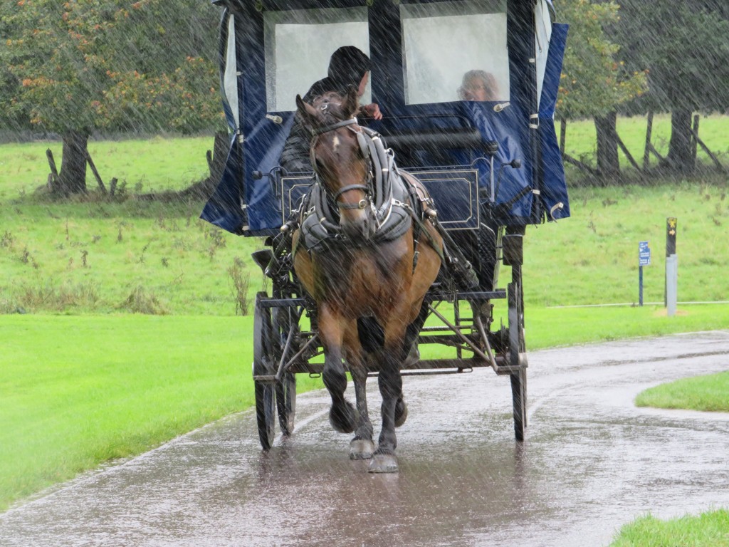
This was a day of continual heavy rain, interspersed with intervals of torrential downpours. In poor visibility, we headed for Killarney and although it wasn’t our original plan, decided to begin the day indoors, in the hope that the weather might improve. Spoiler alert – it didn’t. Killarney is noted for its horse and cart trips. These are known as jaunting cars and as we drove up to our destination, Muckross House, we accidentally ended up at the jaunting car entrance instead of that for regular cars. We manage to end up where we needed to be and were pleased to see that this wasn’t quite so overrun with tourists as some other places we’ve been.
The Herbert family settled at Muckross in the early 1700s. In 1837, Henry Arthur Herbert married May Balfour, who he met whilst on his Grand Tour and they commissioned Muckross House, which was completed in 1843. Henry became an MP and they entertained Queen Victoria at Muckross in 1861. The estate was heavily mortgaged and was let for hunting and fishing. There was certainly a preponderance of dead animals on display, including the ubiquitous 10,000 year old Irish Elk antlers. The estate was sold firstly to a member of the Guinness family and then to the Bourn family, before being given to the nation in 1932; it became Ireland’s first National Park.
I particularly wanted to see the traditional Irish farms, which were adjacent to Muckross House. Had we followed the route I tried to persuade the satnav to take us, we would have arrived here on time for them opening at 1pm, having circled Killarney National Park first. Clearly the satnav though only a lunatic would want to climb narrow mountainous paths in driving rain so we ended up in Muckross rather earlier than intended. Having exhausted the craft shops and resisted the temptation to buy stuff we didn’t need, the only remaining indoor option was the café, remarkable for its amazing selection of cakes. We made our refreshments last as long as possible then I swapped my not actually as waterproof as all that shoes for wellies and we took a quick and very damp tour round the grounds.
Next, an equally damp but worthwhile visit to Irish Traditional Farms, depicting a small, medium and large farmhouse from the area, as they would have been in the 1930s, although the actual buildings were older. There were people in the buildings to tell us their history and each farm was equipped with livestock. There was also a working blacksmith, who demonstrated his craft with incredible skill.
Having completed our tour, we debated whether to go straight back to the van or to go via the scenic route. Given the weather, there would be precious little scenery visible, so we decided to call it a day and head for home. Ironically, when I was first planning this trip in 2019, thinking it might be in 2020, when clearly it didn’t happen and when I was revising the plans for this year, I was reassured that the only family history that might be involved was the visit to Ballyedmond. It wasn’t until this point in the holiday that I remembered that some of my grandchildren were 1/16th Irish. To be fair, I don’t think I knew this in 2019. Arggh. What ancestral locations had I missed? A quick rush to the research notes. It turns out that all I know is ‘Ireland’. A bit more work and my strong suspicion is Tipperary. I will have to leave the ancestral photography to them if they ever visit.
As we didn’t have too far to travel and we didn’t want to arrive before check in time, there was time for a look round Adare first. We have already seen quite a bit of the main and almost only, street from the car, as the traffic doesn’t tend to flow very quickly through the town. Adare is a very pleasant looking settlement, much of which is a nineteenth century estate village, with attractive thatched cottages, set out by the Earl of Dunraven. We found a free car park on the outskirts of town; possibly rather more outskirtsy than ideal. First stop was the heritage centre where we could have booked a guided tour if we’d had time. There was a small exhibition which rather gave the impression that it was no longer a priority. Here we learned that Adare Castle was built in 1220 and was owned , briefly, by Geoffrey de Marisco in the 1220s. Cromwell ordered the dismantling of the castle in 1657 and most of the village was destroyed. We wondered if this was the same Marisco family who owned Lundy Island. We had a quick look in Adare’s Catholic Church but the incense was a bit overpowering for a long stay; it was once part of Ireland’s only Trinitarian Monastery, founded in 1230. The aim of the Trinitarian Order, which originated in France, was to rescue those who had been taken hostage in the Holy Land during the Crusades. There is also an Augustinian Friary in Adare, founded in 1315 by John FitzThomas FitzGerald. It was known as the Black Abbey, from the colour of their habits.
We drove on to our penultimate campsite at Glenbeigh. En route there were numerous charity collectors in the middle of the road at junctions, roundabouts and traffic lights. We have also seen this elsewhere This did seem to be effective, if inordinately dangerous. I can’t believe the charity’s risk assessment takes account of this. The route took us through the beautiful Kerry countryside and the site is nestled at the foot of the mountains, close to the coast. There is more heavy rain forecast for the next week, We can only hope that the forecast is about as accurate as it has been for the past few days.
Day 25
This was the day that our luck with the weather finally ran out. Undaunted, we set off in mist and rain to err ‘view’ the scenery of the Dingle Peninsula, well in theory anyway. A clear sunny day would have been glorious but it could have been worse and we did see some spectacular views through the drizzle and cloud. There’s a Ring of Kerry and a Ring of Beara but no Ring of Dingle, probably because the Brandon Mountain gets in the way. Instead, there is more of a figure-of-eight that takes you round the Dingle Peninsula.
We started heading westwards along the south coast of the peninsula, dropping south of the N86 between Anascaul and Dingle, to remain as close to the coast as possible. The route we took is highly recommended, especially if you aren’t blessed with a rainy day when the wind was strong enough to make it difficult to stand up straight. It also requires a driver who isn’t fazed by single-track, twisty roads and who can reverse up the same when something comes in the opposite direction.
We paused for a short while in Dingle to see if there were any interesting fishing boats; there weren’t. Then round the westernmost point and back to Dingle before heading northwards between Brandon Mountain and Stradbally Mountain. Inevitably, this took us up and what goes up must come down, so down as well. Here we were warned that we should turn round if our vehicle was more than six foot wide. We were pretty sure the car was indeed more than six feet wide but things seemed to be coming the other way, so we pushed on. There was a scarily sheer drop to my left and not very far to the left either. On the right towered the granite cliffs, as the narrow road twisted back and forth and we were rewarded with the sun shining on the north coast. Despite the limitations of the weather, the Dingle Peninsula has edged into first place on my best scenery list.
The satnav was deliberately set to shortest route, rather than quickest, which meant that we did not travel on the N70 from Tralee to Castlemaine but on the road that passes through the Slieve Mish Mountains. It is definitely worth going this way if you are confident driving in the conditions mentioned above.
Next was a supermarket shop in what was probably the most inadequate supermarket imaginable. It began by us circling said supermarket looking for its car park, only to discover that there wasn’t one. We secured an on street parking space and then found a distinct lack of things that we were hoping to buy. To top it all, there was only one check out and we arrived with our modest basket full (it would have been less modest if they’d had what we wanted) just as someone began unloading €200 of shopping.
Sorry for the break in transmission. We are now safely back home but you still have a way to go, partly because I don’t normally post holidays in real time but also I’ve been hampered by being in places where the wifi required me to huddle under a tree and for most of the time we were on that site it was raining.
It was time to head eastwards and for once, avoid the outskirts of Limerick. We drove through Tipperary. It has indeed been a long way for us, 2193 miles since we left home. We arrived at Rock of Cashel, another of the guide book’s top ten, coming in at number nine. This meant the inevitable thirty strong queue for the toilets. I decided I could wait. It was just as well, as this meant we arrived just at the right time. A flash of my English Heritage life membership card and we were whisked through like VIPs to join the guided tour that had just started. Rock of Cashel was the seat of the kings of Munster from the fourth century until 1101, when it was given to the church. Brian Boru, later High King of Ireland, was crowned here in the tenth century. On the site is St. Patrick’s Cathedral, a defensive tower house, the hall of the Vicar’s Choral and a round tower.
We went into the Cathedral first. St. Patrick’s Cathedral was built in the thirteenth century and replaced an earlier structure. The tower was added in the fourteenth century. It is a gothic, cruciform cathedral with an exceptionally short nave. Normally the nave is twice as long as the choir. Initially, the lack of space meant that they were built the same length but to make room for the tower house, the nave was shortened further to become just half the length of the choir. This was thought to make the cathedral unlucky. The height of the lancet windows was reduced by a third when stained glass was installed. This was a money-saving exercise, as the glass was so costly. Following the Reformation, the Cathedral was Protestant but it was taken over as a Catholic Cathedral in 1641. The Earl of Inchiquin regained it for the Protestants in 1647. He arrived with 2500 soldiers to find 800 people taking refuge in the cathedral, guarded by just 300 soldiers; they were all massacred and the interior of the cathedral was destroyed. The building was abandoned in 1748 and some of the roof removed to avoid paying tax. Massive storm damage in 1848 led to further deterioration. Fragments of a thirteenth century wall painting survived because it had been plastered over after the Reformation. It was rediscovered when a builder accidentally knocked off some plaster.
There were spectacular views from the rock across, we were told, ten counties and we had clear blue skies; luckily the forecasters got today wrong. In a field below was Hore Abbey, also known as St Mary’s of the Rock. It was founded in the 1270s as a Benedictine Abbey but the Archbishop David MacCarwell evicted the Benedictines in favour of the Cistercians. The legend is that this was because he’d had a nightmare in which he was murdered by Benedictines. He was unpopular for spending money that was earmarked for the building of a hospital on the abbey.
Our precipitate arrival meant we had the magic green wristband that allowed us entry into Cormac’s Chapel. There was extensive restoration in 2009, in order to try to remove the moisture from the chapel and visitors are now limited because they tend to breathe, which was having a detrimental effect. Cormac’s Romanesque Chapel was built between 1127-1134 by Comac MacCarthaigh, King of Munster. It contains the first known spiral staircase in Ireland. Entrance is now via the back door under a tympanum depicting an animal that is probably meant to be the bull of St. Luke, despite it looking like a hippopotamus. The front door was blocked off by rival kings. There is a twelfth century sarcophagus inside that has Scandinavian style decoration. It was moved to the chapel from outside to preserve it; this involved removing a wall. There are also some remnants of frescoes from the 1170s, when Henry II visited Ireland and convened the Synod of Cashel. They were done by an artist who also decorated Henry II’s chapel in Normandy and they use expensive pigments including lapis lazuli from Afghanistan.
We looked in the Hall of the Vicar’s Choral, built in the 1420s by Archbishop O’Hedian. This has been styled as it would have been at the time, which means there has been heavy restoration and use of replicas, which is a shame.
There was a bit of a debate about whether we should move on to Kilkenny, which was a further thirty eight miles east and eighty five miles from our campsite but it was, after all, number three in the guidebook charts. We decided to go for it. On arrival we had to look for a car park, which was fairly easily found and very cheap. It did seem to be at the ‘wrong’ end of the city in quite a run down area. There had been signs to the Castle from 40km away but once in the city, could we see any? Of course not. You’d think you could see something like a castle from a way off but no. Fortunately, our instincts were correct and it wasn’t too far away.
Kilkenny Castle, on the banks of the River Nore, was a twelfth century fortress, built by William Marshal. For six centuries it was the home of the Butler family until, having already auction off most of the contents, the 6th Marquis of Ormonde sold it to the people of Kilkenny for £50 in 1967. It is now maintained by the Office of Public Works. It was extensively remodelled in the nineteenth century. Eighteenth to twentieth century exhibits from a wallpaper collection were on display. There were also seventeenth century tapestries based on a design by Reubens. Here we saw some more 10,000 year old Irish elk antlers. The animal stood at a height of seven feet. I was most impressed by the picture gallery, not for the art but for the elaborately painted ceiling. The gallery was built in the nineteenth century. We did manage to acquire the first ice cream of the holiday. It seems that most places have assumed that the ice cream eating season is over as we’ve seen many empty fridges.
I am willing to admit that perhaps we somehow missed the best bits but although interesting, I am not quite sure whose palm Kilkenny greased to warrant being number three in the guide book’s top ten. I will reveal my own top ten at the end and no one has greased my palm. I could be open to offers!